
PARASOL
 |
The PARASOL (Polarization and Anisotropy of Reflectances for Atmospheric Science coupled with Observations from a Lidar) payload consists of a digital camera with a CCD detector array, wide-field telecentric optics and a rotating filter wheel enabling measurements in 9 spectral channels from blue (0.443 µm) through to near-infrared (1.020µm) and in several polarization directions. Polarization measurements are performed at 0.490µm, 0.670µm and 0.865µm. Because it acquires a sequence of images every 20 seconds, the instrument can view ground targets from different angles, +/- 51° along track and +/- 43° across track.
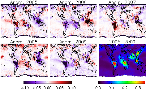
Three-month (September through November) global fine-mode AOD at 550 nm. Bottom right : average over 5 years (2005–09) and anomalies for each individual year. Blue color indicates AOD lower than the average whereas red indicates higher values (Tanré et al., 2011)
| Satellite | PARASOL (CNES) |
| Instrument(s) | POLDER |
| Instrument / Algorithm PI | Didier Tanré, CNRS/USTL |
| Contact Details | didier.tanre[at]univ-lille1.fr |
| Parameter(s) | ocean: AOD (2 modes) and size/ land: AOD (fine mode) |
| Aerosol algorithm | LUT approach |
| Cloud screening | Internal |
| Aerosol model | 2 modes (Fine and Coarse) / Non-spherical dust particles (two spheroid models) |
| Retrieval assumptions | Assumptions on the BPDF of the land surfaces |
| Retrieval limitations | Coarse mode is not retrieved over land |
| Spatial, temporal coverage | March 2005 - September 2013 / Global |
| Spatial, temporal resolution |
level 1: 5x6 km2 / level 2: 17x18 km2 / Swath: 1600 km / 16 days repeat cycle |
| Operations status | Operational / reprocessing |
| Validation status | AERONET comparison |
| Quality control | Fitting errors / Viewing geometrical conditions |
| last algorithm version | 11.11 (ocean) 10.10 (land) |
| last validation |
Level 1: final reprocessing achieved in November 2014; Level 2 and 3: ongoing |
| Algorithm description | Product format description |
| Version explanation | Validation summary |
| Publications |
| Product data access |
| Image / quicklook data access |