
GOES GASP
|
|
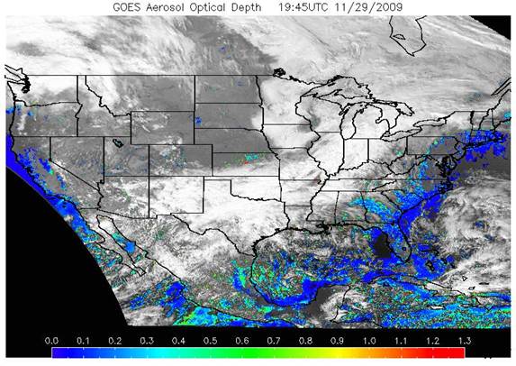
The GASP product is a retrieval of the Aerosol Optical Depth (AOD) made from the current GOES-East and GOES-Westvisible imagery. Satellite measured aerosol optical depth (AOD) has been shown to be a good proxy for pollution monitoring especially when long-range transport is involved. This product is available at a 30-minute interval and 4 km X 4 km spatial resolution during the sunlit portion of the day. Radiative Transfer calculations assume a continental aerosol model and Lambertian surface. Comparisons of GOES AOD with AERONET AOD show that GOES data are accurate at the 30% level for AODs greater than 0.1.
|
Example result / latest result (if near-real time)
|
 |
| Satellite: | GOES (NOAA) |
| Instrument(s): | GOES-East and GOES-West |
| Instrument/algorithm PI: | Shobha Kondragunta and Matthew Seybold (NOAA) |
| Contact details: | Shobha.Kondragunta[at]noaa.gov, Matthew.Seybold[at]noaa.gov |
| Parameter(s): | AOD |
| Aerosol algorithm: | GASP |
| Cloud screening: | CLAVR |
| Aerosol model: | continental aerosol model |
| Retrieval assumptions: | lambertian surface, background reflectance from minimum reflectance of a 28 day period |
| Retrieval limitations: | one fixed aerosol model |
| Spatial, temporal coverage: | NRT, USA domain including Hawaii and Alaska |
| Spatial, temporal resolution: | 4x4km² / geostationary / 30 minutes repeat cycle |
| Operations status: | operational |
| Validation status: | intercomparison with ground-based and MODIS observations |
| Quality control: | QA/QC based on viewing geometry (solar zenith angle and scattering angle), spatial variability tests, and surface reflectance. |
| last algorithm version: | No version number but algorithm updated in January 7, 2009 |
| last validation: | Prados et al., JGR, 2007 |