
Antarctic Ozone Hole Size
GOME-2 Near-Real-Time Service
GOME-2 level 4 data products are generated at DLR in near-real-time in the framework of WDC and the EUMETSAT Project AGORA.
GOME-2 NRT Products (level 4)
| Antarctic O3 Hole Size |
| Latest Results |
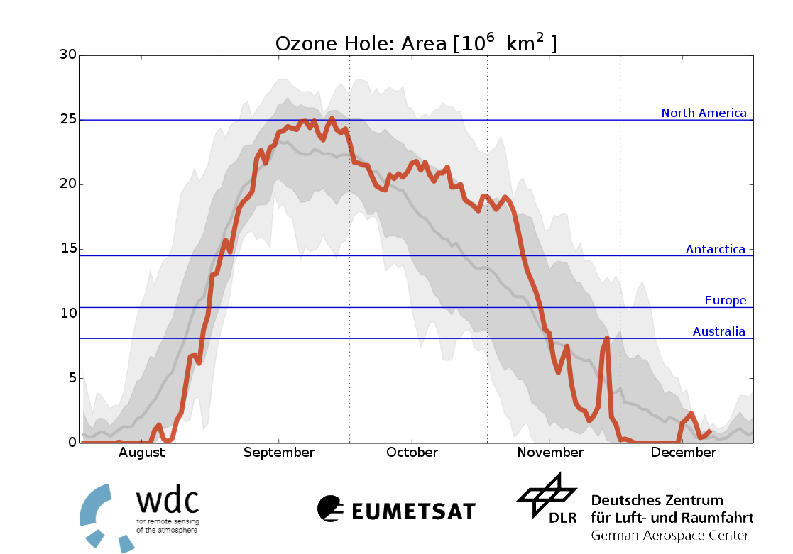 |
| Description: By the anthropogenic release of halogenated hydrocarbons (which were banned by the Montreal Protocol in 1987) and their photolytic destruction in the stratosphere, inactive chlorine and bromine species are formed. These so called reservoir species are activated in the vicinity of the coldest regions within the stratosphere on the surface of so called polar stratospheric clouds (PSC). Activated halogens can efficiently destroy ozone in a catalytic cycle and are responsible for massive ozone loss. This catalytic cycle takes place in the sunlit regions and therefore remarkably follows the dawning sun over south pole region. The figure includes the development of the ozone hole size for the years 2007 to 2016. The current year's development of the ozone hole is illustrated by the red line. The interval between daily minimum and maximum ozone hole extensions is depicted by the grey shaded area, the 1-sigma interval is denoted by the darker grey and its yearly mean evolution by the dark grey line. The ozone hole sizes are derived using the ROSE/DLR Chemistry and Transport Model (CTM) assimilating total ozone columns derived from MetOp/GOME-2 measurements. To allow the comparison of the ozone hole extents, only trace gas information derived from GOME-2 as well as an equivalent model setup was applied. The size of the ozone hole is defined as the area where the total ozone columns amount is below 220 DU. |
For further information on GOME-2 data, please contact wdc@dlr.de.